|
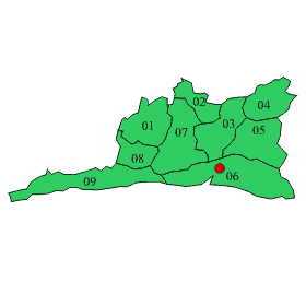
Province located in the south of Cuba's eastern region. It has an extension of 6 162,1 sq km (2379 sq mi) and an estimated population of 1 016 754 inhabitants (1996) distributed in 9 municipalities. The province ranks eleventh in extension and second in population.
Most of the territory is covered by mountains: those of the orographic group of the Sierra Maestra, being its higher point the Turquino peak 1972 m (6468 ft); and the south portions of the Sierra de Nipe and Sierra Cristal. The rest of the territory is occupied by the eastern end of the Cauto plain, the Santiago de Cuba basin, and the central valley. The most important rivers are the Contramaestre, the Guaninicum, and the Baconao.
Insustrial activity is represented by coffee and sugar production, port activity, and cattle raising.
 |
| Municipality |
01 Contramaestre
02 Mella
03 San Luis
04 Segundo Frente
05 Songo La Maya
06 Santiago de Cuba
07 Palma Soriano
08 Tercer Frente
09 Guama
 |
|
| Statistics |
1999 |
| Surface area |
6 170 km2 |
| Resident population |
1 032 508 inh |
| Average population |
1 030 210 |
| Female population |
49,9 |
| Population in working age |
614 719 |
| Urbanization index |
69,6 % |
| Population density |
167,3 inh/ km2 |
| Life expectancy at birth (1994-1995) |
75,11 |
| Birthrate |
13,9 |
| General mortality rates (per 1000 live) |
6,0 |
| Infant mortality rate(per 1000 live births) |
6,0 |
| Fecundity global rate (children per woman) |
1,54 |
| Reproduction gross rate (daughters per woman) |
0,75 |
| Inhabitants per physician |
167 |
| Inhabitants per dentist |
1 037 |
| Initial matricula (Course 1999/2000) |
238 050 |
| Primary education |
99 832 |
| Intermediate education |
97 265 |
| Higher education |
12 614 |
| Graduates (Course 1998/1999) |
47 810 |
| Primary education |
17 200 |
| Intermediate education |
25 585 |
| Higher education |
1 851 |
|